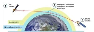
[Via Satellite 06-08-2015] Commercial weather data startup PlanetiQ could look to build a larger constellation of satellites based on the successful test of its Pyxis Radio-Occultation (RO) sensor. The company recently began testing the processing of Global Positioning System (GPS) signals with the sensor, which will eventually form the heart of a constellation of GPS-RO satellites.
Based largely on the work of PlanetiQ Founder Chris McCormick, who also had a primary role in designing the U.S.-Taiwan Constellation Observing System for Meteorology, Ionosphere, and Climate (COSMIC) GPS-RO sensors, the Pyxis builds on COSMIC’s Blackjack sensors and COSMIC 2’s Trig sensors. According to Anne Hale Miglarese, president and CEO of PlanetiQ, the new sensor is tiny enough to reduce the projected size of each spacecraft, potentially creating an opportunity for more.
“This instrument is dramatically smaller and lighter weight than the Blackjack or the Trig, which allows us to put more in orbit for a lower price. We are looking at a satellite and sensor all in at about 22 kilograms at the most right now,” Miglarese told Via Satellite.
PlanetiQ has a planned constellation of 12 satellites that would provide global coverage spread equally around the world. The microsatellites are expected to deliver more than 8 million observations of temperature, pressure, and water vapor per day. Thanks to the new sensor, Miglarese described 12 as the minimum ideal constellation.
“Assuming the market is supportive, we would like to go to at least 18, if not 24 satellites. Some recent research by the European Commission for Medium Range Weather Forecasting and statements by [the U.S. National Oceanographic and Atmospheric Administration] NOAA have articulated that you could have 128,000 occultations a day and still not saturate the forecast models. It would still make those forecast models better, and we believe that there is room for more of this data to drive a better global weather forecast,” she said.
Though widely referred to as GPS-RO, such systems, including PlanetiQ’s, can often leverage signals from multiple Global Navigation Satellite Systems (GNSS) to collect a greater amount of data. PlanetiQ’s Pyxis sensor can track signals from the U.S.’ GPS, Europe’s Galileo, Russia’s Glonass and China’s BeiDou GNSS constellations. Miglarese said one of the biggest improvements with Pyxis is in the Signal to Noise Ratio (SNR), which will enable the sensor to penetrate close to, if not completely down to the surface of the Earth. PlanetiQ has been developing the sensor for roughly a year and a half with several partner organizations, but has now shifted all work in-house.
“We are testing at the end of the month the ability to simulate exactly what the occultations are looking like, so we will be able to simulate the data. Our hope is to complete all of the testing roughly by the first of August,” she said.
PlanetiQ is still raising capital for its proposed commercial weather constellation and just closed a funding round. Miglarese said the company has two instruments fully funded and in production today, and will likely have two more funded through the most recent round. She described raising capital as an iterative fundraising activity, as the startup just opened another round of funding. PlanetiQ’s goal with the newly opened round is to fund four more sensors. The company hopes to self-fund the last six, or possibly more, to round out the initial constellation.
Miglarese noted that PlanetiQ does have customers lining up to purchase data from the constellation once it is active. NOAA is not among them, though the list includes a mixture of large government weather prediction centers internationally and various commercial entities.
“We have letters of intent from customers around the globe. We do not have one from the United States government. With that said, I do believe NOAA is warming up to the idea,” said Miglarese. “Seeing how there are no commercial weather satellites selling meteorological observations at present, this is a cultural sea-change for national weather prediction centers, and one should expect that they are going to be careful if not skeptical. Their focus at present is on making sure that it’s high quality data, and we certainly support that.”
The Weather Research and Forecasting Innovation Act, which recently passed the U.S. House of Representatives, directs NOAA to publish its standards for GPS-RO and other space-based commercial data. Miglarese said she is confident PlanetiQ will exceed them.
The first two of PlanetiQ’s satellites are slated to launch in the September-October timeframe in 2016, followed by four more in early 2017. Miglarese said the company is now in negotiations with a foreign launch provider for the first launch. She said PlanetiQ intends to always fly as a secondary payload because its satellites have on-board propulsions which they can use to reach their 800 kilometer, 72 degrees inclination orbit. Each satellite is built with a design life of seven years.
The post PlanetiQ Pyxis Sensor’s Success Could Lead to Larger GPS-RO Constellation appeared first on Via Satellite.
